Itinerary: Six Days in Southern Utah

I’m spending some time this weekend sorting through photos from our trip to southern Utah and I can’t wait to share them! This trip is something my husband especially has been looking forward to for awhile. It came from one of those conversations where we ask each other, “If you could go anywhere in ‘X Country,’ where would you go?” This spring we’d earmarked a week for a U.S. trip, and we both agreed it was time to tackle southern Utah.

Utah Road TripGoing in, neither of us knew exactly what to expect, but I have to tell you, this trip has made its way into my top three for scenic beauty. Per usual, we packed a TON into just six days, but we never felt rushed – which makes it a very successful road trip in my book. Read below for a detailed itinerary of six days in southern Utah:

Day 1: Las Vegas, St. George
We flew in and out of Vegas, because it was the least expensive flight from our home airport. We’d both been to Vegas before, so we opted not to spend the night. Instead, we spent about five hours walking the strip, having lunch (at Flour & Barley, highly recommended for wood-fired pizza and an extensive beer menu), touring the National Atomic Testing Museum, and drinking beer flights at CraftHaus Brewery. From there, we drove two hours to St. George, Utah, where we spent our first night.

Day 2: Zion National Park in Springdale, Utah

Zion National Park Observation Point

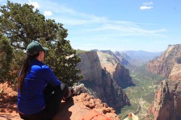
Observation Point in Zion National Park

We woke up at sunrise, packed our backpacks, and jumped in the car headed for our first national park of the trip. When we arrived in Springdale (about an hour from St. George) we grabbed a quick but hearty breakfast and made our way into the park. Quick tip – the national parks in Southern Utah, like many, require a day fee per vehicle of $25-$30. If you plan to see several, buy the America the Beautiful Inter-Agency pass. It’s $80 and worth it if you’re seeing at least three parks on your trip (or within one year, which is how long the pass is valid).


Zion National Park Pa'rus Trail

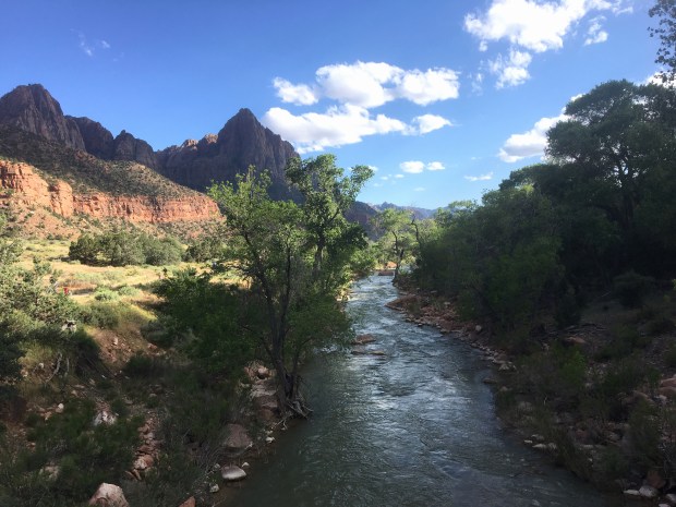
The Virgin River along Pa’rus Trail in Zion National Park

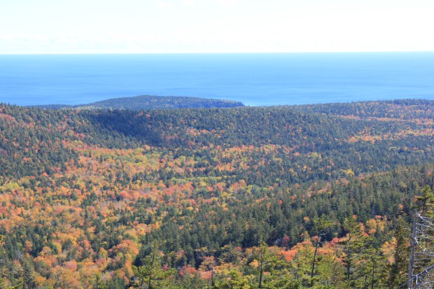
By 9 am, we were on the trail to Observation Point. This 8-mile steep out and back trail is labeled as strenuous, but the view at the top is so, so worth it. After a late lunch at Zion Brewing Company and some souvenir shopping, we went back out for a 3-mile out and back hike on the Pa’rus Trail. This easy trail is flat and follows the Virgin River as it winds through the park. It was the perfect way to end the day in Zion.


Day 3: Bryce Canyon National Park, Page

Red Canyon Bryce Canyon National Park

Red Canyon near Bryce Canyon National Park

Bryce is about an hour and 45 minutes from Springdale/Zion, so we got an early start on our drive. On the recommendation of our beertender at CraftHause in Las Vegas, we stopped first at Red Canyon, just 10 minutes outside of the national park, where we were able to get up-close and personal with the hoodoos this area is known for.


Bryce Canyon National Park

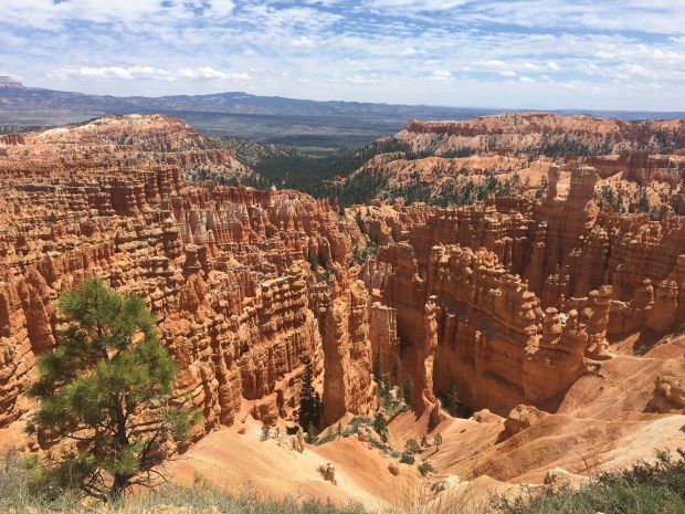
Views of Bryce Canyon National Park’s famous hoodoos from the East Rim Trail

From there we made our way into the park and directly to Bryce Point, arguably the best overlook in the area. From there, we jumped onto the East Rim Trail, which winds around the edge of the canyon. In roughly two miles we’d made our way to Inspiration Point, and then on to the famous Sunset Point. A quick shuttle ride back to our car at Bryce Point, and we were back on the road. Our hotel for the night was in Page, Arizona, where we’d spend the following day.


Day 4: Horseshoe Bend, Lower Antelope Canyon, Lake Powell, Monument Valley
Horseshoe Bend Page ArizonaPage, AZ is a small town built in the middle of some absolutely amazing scenery. When we woke up, just after sunrise, we went immediately to Horseshoe Bend. We just missed the crowds who’d arrived to watch the sunrise, and had the view mostly to ourselves for the next hour.

Lower Antelope Canyon Page ArizonaNext up, we toured Lower Antelope Canyon. This was SO COOL, and 100% worth the price of admission.

Lake Powell Glen Canyon National Recreation Area Page Arizona
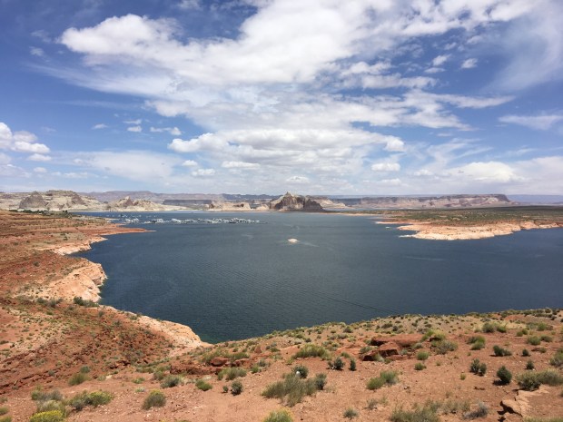
Lunch at Big John’s Texas BBQ was the food highlight of our trip, and fueled us up before we drove through Lake Powell/Glen Canyon Recreation Area (also a fee area, but covered by my America the Beautiful pass!). The views here honestly looked fake, as if it was a painting we were looking at. The photos just don’t do it justice.

Monument ValleyAnother two-hour drive led us to Monument Valley. Our first stop was mile marker 13, where Forrest Gump just stopped running. From there we took in the views, pitched our tent at the campsite, and waited on the sunset.

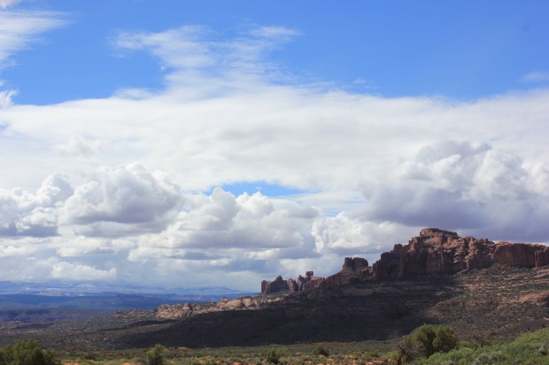
Day 5: Moab, Canyonlands, Colorado River
Canyonlands National Park Moab UtahWe’d intended to hike the Arches on day five, but Mother Nature wasn’t having any of it. After a three-hour drive from Monument Valley to a rainy Moab, we decided to grab lunch and drive through the Canyonlands. The clouds (and SNOW!) at the top prevented us from getting the full effect, but as we made our way back down the mountain we were able to see some pretty spectacular views.


Big Bend Campground Colorado River Moab Utah

Big Bend Campground along the Colorado River near Moab, Utah

We spent the rest of the day on touristy things – shopping and beer-ing at Moab Brewing Company. Early in the day, we’d staked out a spot at Big Bend Campground, and headed there before sunset to make a fire and enjoy our last night in Utah.


Day 6: Arches National Park, Las Vegas
Arches National Park Moab Utah
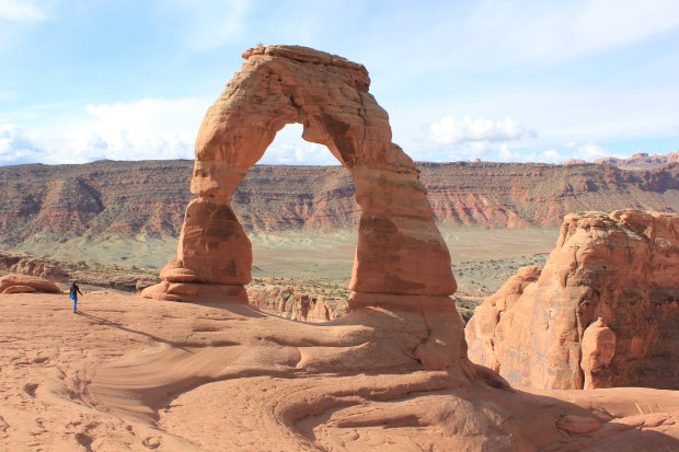
We woke up at our campsite along the Colorado River, and the sun was trying to make its way out from the clouds. We decided to head straight over to the Arches, and by the time we arrived, around 8:30 am, we were greeted by blue skies. We made the three-mile out and back trek to Delicate Arch, and it was the perfect way to end our trip.

From Moab, it took us about six and a half hours to drive back into Las Vegas. With a red-eye flight that night, we didn’t have much time to spare. But, we managed to sneak in dinner at a place that just really gets me – Tacos & Beer.


I can’t say enough about the scenery, the parks, the people. Southern Utah will go down as one of the best road trips we’ve done, ever. Look for more detailed accounts of some of our hikes and activities in the next couple of weeks! Have you been to Southern Utah? What was your favorite activity? Let me know in the comments.

Advertisement

4 Easy Ways to Keep the Travel Bug At Bay

I’ve been home for about two weeks since my last trip, a whirlwind tour of the Pacific Northwest. And per usual, the travel bug has come back to bite me already. But let’s be honest – I don’t have the vacation time or the cash handy to drop what I’m doing and hop another plane.

Instead, I’ll be employing these 4 Easy Ways to Keep the Travel Bug at Bay while I save up for my next adventure.


view-from-carew-tower-in-cincinnati-ohio

View from Carew Tower in downtown Cincinnati

Be a tourist in your own city. I live just outside a mid-sized Midwest city, but there’s so much to see and do. It may not be NYC or LA, but new restaurants are opening downtown every week, art exhibits, ballets and broadway shows are plentiful, and the outdoor adventure scene isn’t too shabby, either. In my down time from travel, I find that getting out and about in my city is a great way to do a lot of the things I love, like hiking and trying new restaurants and breweries, without forking over the money for a plane ticket or hotel room.


red-river-gorge-in-daniel-boone-national-forest

Red River Gorge in Daniel Boone National Forest is just a two-hour drive from my city

Plan a day trip. Where can you drive to in under three hours from your hometown? I can get to three other mid-sized cities, a National Forest, and the Kentucky Bourbon Trail, to name a few. Sure, it can be a lot of driving in a day. But with the right travel partner(s), it’s the perfect way to get that quick fix you’ve been craving.


looking-glass-rock-in-pisgah-national-forest

Looking Glass Rock is in Pisgah National Forest, just one hour outside of Ashville, NC

Find your go-to weekend getaway. Not everyone is into the idea of repeat trips, but for me, after awhile you know what you like and what you don’t like. And if you can find a place you like within a reasonable distance for a weekend getaway, make it yours. I love, love, love Asheville, North Carolina. Not only is it a quirky city with INCREDIBLE beer, but it’s within an hour’s drive to multiple National Forests and Parks. Hello, mountains! I’ve been in the area three times now, and am planning a fourth trip near Thanksgiving this year. Each time I visit, I find something new and incredible, and until that stops, I’ll keep visiting. It’s under five hours’ drive time, and the perfect weekend getaway for me.


travel-planning-tips
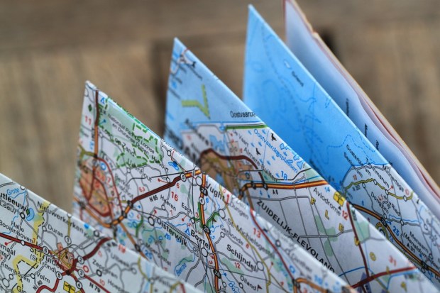
Research and plan for your next big trip. What better way to get excited than to research your next big trip? Sure, it might not happen for six months or a year, but you can use that time to discover destinations you never knew existed, add to your itinerary, or brush up on some useful language skills (if you plan to travel internationally). If you’re planning a particularly large trip that’s more than a year out, researching and budgeting can help you stay focused on your travel savings plan, and you’ll have plenty of time to find the best deals on transportation, lodging and attractions. Traveling and experiencing new things is the best – but planning for them is a close second, in my book.

What’s your best tip for keeping the travel bug at bay? Let me know in the comments!

Hiking Oregon’s Oneonta Gorge

If you’ve ever visited Portland, or thought of visiting Portland,  you’ve probably come across more than a few opportunities for nearby outdoor activities. Just 35 minutes from downtown Portland is a well-known area called Multnomah Falls. It’s gorgeous – waterfalls, greenery, the opportunity to hike up to the top or down to the bottom.

gorge1
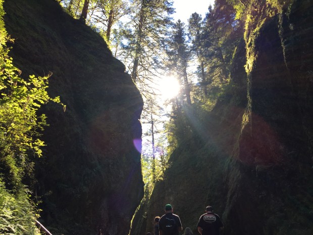
Keep going – five more minutes and you’ll arrive at Oneonta Gorge. Where Multnomah has multiple parking lots and shuttles that drop you off at the falls, Oneonta has parking along the roadway. And though it’s by no means deserted, you’re looking at sharing the gorge with 50 people vs. hundreds at the falls.

gorge2Let me tell you what’s incredible about this hike.

To start, it’s stunning. Even better, you can get right into the middle of it, rather than snap a far-away photo. Here’s how:

gorge4You hike through the water. No dry paths here! This is the best thing about hiking for me – that feeling when you see something so beautiful, but you don’t have to just look from far away. You can get into the thick of it. This hike goes to the extreme, dropping you into chest-deep water (only for a moment) and leading you straight to the heart of the gorge.

Oneonta Gorge in Columbia River Gorge National Scenic Area

But first, you have to scramble over these rocks and logs. It’s a bit tricky, considering there could be as many as 20 people trying to go in opposite directions – some are just finishing, while others are just beginning, and there’s only one way in and out. Go slow and be cautious, because the rocks and logs are wet and slippery. And if you can, wear a pair of water shoes with good grips on the bottom. It makes a world of difference. Bare feet on the stones in this river bed? Not a good idea.

gorgeb1Real talk: that water is cooooollllddd. The worst part is the first few steps into ankle deep water. Ever had to ice your foot after running or playing sports? It’s a little painful. But once you go deeper – it’s a gradual decline, from ankles to knees to waist, and then eventually chest deep – it just becomes thrilling, honestly. Look at the smile on my face! I was exhilarated.

gorge3
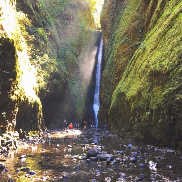
Just after you emerge from the deepest water, you’re in the middle of this gorgeousness. It’s not more than 15 minutes to get there, but by the time you see this waterfall you know you’ve worked for it.

A few tips: I bought cheap water shoes on Amazon that I didn’t feel bad about throwing out – nobody wants to bring wet, smelly shoes home on the plane! I wore quick-dry clothes, and brought a towel and  a change of clothes for directly after. I brought a small backpack (that I had to carry over my head) with very few items. The camera went into a gallon-sized plastic bag, inside the backpack – just in case.

Have you hiked Oneonta Gorge? What other unique hikes have you done? Tell me in the comments!


Jordan Pond in Acadia National Park

Hiking in Acadia National Park

Fall on the east coast is incomparable, and travelers from all across the country head to New England in October to chase the colorful leaves down the coast. Leef peepers often start in Maine and drive south to capture photos of the season’s most beautiful colors.

Autumn in Maine

This past fall, I was lucky enough to time a trip to the onset of fall foliage in Maine, and take some gorgeous photos during a hike in Acadia National Park. It was the weekend after Columbus Day – which is typically a very busy tourist time in Massachusetts and Maine. By that next weekend, most tourists had departed but the colors were just reaching their peak.

Acadia National Park in Maine

I hiked in Acadia on the tail end of a road trip from Boston to Bar Harbor, and after gorging myself on lobster rolls and clam chowder, I was ready for a longer, more strenuous hike.

Pemetic Mountain, South Ridge Trail Loop – 6 miles, advanced

Acadia’s mountains were different from any I’ve hiked in the past. These beauties are forested near the base, but as you climb higher, they open up to stunning granite formations. Hiking up Pemetic Mountain on the South Ridge Trail Loop takes you on a path around Jordan Pond, through the forest, and finally up above the evergreens. By the time I reached what I thought would be the summit, I had to take a breather and enjoy the gorgeous views.

Acadia National Park

After another half hour’s climb, I reached a clearing and this stunning vista.

Acadia National Park

But wait, there’s more! Keep trekking up and over the final hill to the highest point, and here’s what’s in store:

Pemetic Mountain in Acadia National Park

My husband, Mike, at the tip top of Pemetic Mountain in Acadia National Park

Rather than backtrack down South Ridge Trail, I decided to follow the connecting North Ridge Trail down the  mountain, so that I could take the famed Carriage Roads back to the Jordan Pond lot where the car was parked. I would share a photo, but I was too busy concentrating on not doing permanent damage to my knees, or falling flat on my face to snap a shot of the descent. That trail was STEEP. Take your time on the way down, and move as slowly as you need to. From jumping off of boulders and cursing myself for not bringing a walking stick, it was tense at times. But, I made it in one piece.

And boy, were those carriage roads worth the trip! So charming I forgot to take a photo. What kind of blogger am I, anyway? You can read more about the carriage roads here. Another quick 1.5 miles later, I’d reached my car and the Jordan Pond parking lot.


Acadia National Park

Hey, I made it! This is my super happy face after finishing the five-hour trip up and down Pemetic Mountain. Enjoying Maine’s incredible coastal views.

This hike was one of the more difficult hikes I’ve encountered, mostly due to the steep decline. But the views were oh so worth it. All in all, it took me five hours, with many breaks and time spent sitting down to enjoy the panorama of Maine in October.

What’s your favorite trail in Acadia National Park? Let me know in the comments!

Hiking the Rocky Mountains for Beginners

Hiking the Rockies for Beginners

If you’re like me, you can’t just stare at the mountains – you have to go into them to explore. Denver makes a terrific home base for exploring the Rockies, and it’s in proximity to tons of hikes suitable for beginner and intermediate hikers. Here are just a few of the trails I recommend:

Dream Lake in Rocky Mountain National Park – 2.2 miles, easy

Hiking in Rocky Mountain National Park

Rocky Mountain National Park is perhaps the most popular hiking area for visiting travelers because it’s so well-known. What makes it even better is the easy access to hiking trails. When you drive into the park (it’s about an hour from downtown Denver) you pay the toll and head straight in. To reach the trailhead that leads you to Dream Lake, you’ll drive along Bear Lake Road and look for signs for a Park and Ride lot. Especially during peak season (May through September), the parking lots fill before 10 am. The Park and Ride lot is equipped with really nice restrooms, water fountains, and a line for the free shuttle bus. Quick tip – the line for the shuttle bus can be quite long, but it moves fairly quickly. Getting an earlier start makes wait times lower and trail traffic less intense. However, this is a well-loved, and highly-traveled trail – so you shouldn’t expect to find yourself alone in the wilderness. There’s plenty of beauty, peace and quiet for all, though.

Dream Lake in Rocky Mountain National Park

Dream Lake in Rocky Mountain National Park

The shuttle bus will take you further up into the park, and drop you off at the Bear Lake Trailhead. From Bear Lake, the trail splits – take it to the left toward Dream Lake. The trail climbs steadily up toward Nymph Lake, which makes a terrific spot to rest and take in the views. Continue around the lake and head up the steep climb that will offer you incredible views on your way up. Your next landmark is the trailhead for Lake Haiyaha. Turn right here to continue to Dream Lake, and enjoy the beautiful scene laid out before you. When I visited (in late September at the peak of fall colors) I sat on the boulders in front of the lake and had a picnic lunch, before heading back to the Lake Haiyaha trailhead and looping around to find it. I had more time and energy, and it was a convenient add-on.

Trading Post Trail at Red Rocks Park and Amphitheater – 1.4 miles, easy

Red Rocks Park and Amphitheater

Red Rocks is known for its amphitheater and the incredible concerts it hosts, but there are also some beautiful hiking trails connected to the park. Trading Post Trail showcases the incredible rock formations, valleys, meadows, and more. The terrain is a little rough, so even though it’s just over one mile long, I recommend hiking shoes. While you’re there, take the time to walk the amphitheater steps and take in the views from the top. It’s truly stunning.

Red Rocks Park and Amphitheater

Lake Isabelle in Indian Peaks Wilderness – 4 miles, intermediate

Lake Isabelle Trail in Indian Peaks Wilderness Area

The trail to Lake Isabelle was a favorite for me, because it was more wild than the other trails. Terrain ranged from lush forest to boulders and stones littering creekbeds that flowed down the mountain. Plus, I saw a moose IRL (from a distance). Located in the Lake Brainard area just outside of Boulder, the hike to Lake Isabelle is stunning. After a quick stroll around Long Lake, simply follow the signs across valleys and streams for two miles to reach Lake Isabelle. This hike only gains 400 feet in elevation, but it had my heart pumping. When you arrive at the top, expect wildflowers, spectacular views, and even a bit of snow – it’s generally found here year-round.

Lake Isabelle Trail in Indian Peaks Wilderness Area

Lake Isabelle in Indian Peaks Wilderness

Lake Isabelle

You can tack on an additional two miles and 1,500 feet in elevation from Lake Isabelle to reach the Isabelle Glacier if you have the time and energy – I opted to head back, and backtracked the two miles to my car.

If you decide to make Denver your home base, be sure to check out the local food and beer scene – after a few hours hiking in the mountains, I thoroughly enjoyed replenishing those spent calories at The Populist, Hops and Pie, Great Divide Brewing Company, River North Brewing Company, and Our Mutual Friend, to name a few.

California Dreaming on Pacific Coast Highway

When I was young, my family didn’t go on many vacations. I was introduced to the absolute wonders of traveling by my husband, who insisted that we take an “epic road trip” for our honeymoon. Oh, and it should be done in a convertible, he said.

3833_10101025954301274_274118493_n

For a girl with little to no travel experience other than lazy beach vacations, I was nervous, to say the least. Where should I even begin to plan a trip like we envisioned? How would we get around? Would we be able to eat good, local food, or would we end up in tourist traps?

It was my first try at planning a trip sight-unseen, and I only had a few days of vacation to work with, so we decided to drive the coast of California. My husband and I each picked our “top priority” city – for me it was San Diego, for him it was San Francisco – and we planned the trip between the two cities.

487644_10101036374194724_1039813215_n

When planning a trip with limited time, it’s easy to convince yourself you can do 100 things if you simply maximize your time. The problem is, you really can’t – and you shouldn’t try to. If you’re a planner like me, you’ve written down all of the sites you want to see and the restaurants you want to try. But if you plan too much in too tight of a time frame, you lose the option to just enjoy the sites, linger over wine, spend an extra hour walking the beach hand in hand, or take the scenic route home. And by scenic route, I don’t mean jumping on the bus in the wrong direction and losing two hours on your way back to Coronado from La Jolla Cove. Although, that could happen, too.

219036_10101033575453424_1399075481_o

Now on to the good stuff – the highlights of our trip. We began in San Diego and spent two nights at a resort on Coronado, which was beautiful. Despite a few detours we did make it to La Jolla cove (pictured above), which I HIGHLY recommend to anyone visiting San Diego. We swam in the 70-degree Pacific Ocean alongside a few other brave swimmers while dozens of seals sunbathed nearby. We roamed the Gaslight district and laid on the beach. We strolled through residential neighborhoods and took a water taxi across the beautiful Coronado Bay. I could have spent another three days exploring the city, but the next leg of the trip was calling.


326844_10101033582249804_739173142_o

Central Wine Country in Paso Robles, CA


Quick tip: if you’re renting a car one-way it can be much more expensive than dropping off and picking up at the same location. Consider picking up your rental car from the airport lot, and find out if your hotel offers a free shuttle service to the airport – ours did and it saved us a $45 cab fare.

We drove 570 miles in two days, and stopped in several cities. One of my favorite things we did was to stop in Paso Robles to do a few wine tastings. It was 10 am, and the only place we found open at that hour for tastings was a small vineyard called Castoro Wine Cellars. My husband and I sat down at the bar and were greeted by a friendly woman who figured out we had no idea what we were doing within 30 seconds. She laughed along with us as she taught us the ins and outs of tasting wine, offering us food samples that paired well with the wines. It was an incredible experience in a beautiful part of the country, and I would go back in a heartbeat.

134421_10101033584939414_543664812_o

During the drive in Big Sur – the views are INCREDIBLE, in case you haven’t heard – we found a few absolute gems thanks to recommendations from a friend who’d done the trip years earlier. First, we hopped out of the car in Julia Pfeiffer Burns State Park and hiked down for this view.

340753_10101033587803674_53175859_o

Next we pulled into a small roadside restaurant called Nepenthe. Coffee, cheese, fruit, and this gorgeous scene were laid out in front of us as we indulged ourselves for an hour at their outdoor tables.

224499_10101036376819464_1285513726_n

When we made it San Francisco, we spent our days walking miles and miles through the city. We did take a trolley tour, which I loved, and spent a morning at Alcatraz. Touristy? Yes. Worth it? Absolutely.

209687_10101033683072754_678756166_o

At the end of the trip, my husband (a graphic designer by trade) put together a video with the song that had become the anthem of our road trip. We took photos and video on our Canon Rebel T2i and mixed in a few shots from our iPhones. It was an incredible keepsake from our trip, and puts me right back into that California state of mind. You can view it here.

Have you driven the California coast? What were your favorite activities? Let me know in the comments!